# A tibble: 85 × 32
enid pac_own org_name org_name_own entity_own role_code role_text assoc_date
1 O200… 054717… TMC HAR… TMC/HIGGINS… O 34 5% OR GR… 2003-02-01
2 O200… 155727… HIAWASS… HIAWASSEE F… O 43 OPERATIO… 2000-08-01
3 O200… 599161… TMC WES… TMC WEST CA… O 34 5% OR GR… 1999-11-01
4 O200… 185029… BACON C… BACON COUNT… O 34 5% OR GR… 2012-12-17
5 O200… 185029… BACON C… BACON COUNT… O 43 OPERATIO… 2002-11-20
6 O200… 226441… BOWDON-… BOWDON- MT.… O 36 5% OR GR… 2012-06-01
7 O200… 226441… BOWDON-… BOWDON- MT.… O 43 OPERATIO… 1980-10-09
8 O200… 498150… HOSPITA… JOHN D. ARC… O 43 OPERATIO… 2014-05-29
9 O200… 498150… HOSPITA… JOHN D. ARC… O 43 OPERATIO… 1990-07-02
10 O200… 418352… PHOEBE … PHOEBE PUTN… O 34 5% OR GR… 2008-02-12
# ℹ 75 more rows# ℹ 24 more variables: first_own , middle_own , last_own ,# title_own , dba_own , addr_own , city_own ,# state_own , zip_own , pct_own , is_for_acq ,# is_corp , is_llc , is_med_prov_supp , is_mgmt_serv_co ,# is_med_staff_co , is_holding_co , is_invest_firm ,# is_fin_inst , is_consult_firm , is_for_profit , …
Geocode
geo_census<-tidygeocoder::geocode(mtt(rhc_enr, zip =substr(zip, 1, 5)), street =address, city =city, state =state, postalcode =zip, method ="census", full_results =TRUE)
Passing 82 addresses to the US Census batch geocoder
ga_county<-tigris::counties(state ="GA", year =2024)ga_county_simple<-rmapshaper::ms_simplify(ga_county)ga_county_simple$mid<-sf::st_centroid(ga_county_simple$geometry)ga_county_simple
Simple feature collection with 159 features and 18 fields
Active geometry column: geometry
Geometry type: GEOMETRY
Dimension:     XY
Bounding box:  xmin: -85.6 ymin: 30.4 xmax: -80.8 ymax: 35
Geodetic CRS:  NAD83
First 10 features:
   CBSAFP CSAFP COUNTYNS CLASSFP METDIVFP     NAME        GEOIDFQ
1   12260   00348794      H1      McDuffie 0500000US13189
2   15260   00351605      H1      Brantley 0500000US13025
3     00326713      H1         Lamar 0500000US13171
4   40660   122 00353665      H1         Floyd 0500000US13115
5   10500   00352238      H1       Terrell 0500000US13273
6   12060   122 01672399      H1    12054  Clayton 0500000US13063
7   12260   00348865      H1      Columbia 0500000US13073
8     00346957      H1         Macon 0500000US13193
9     00357747      H1      Charlton 0500000US13049
10  16340   122 00343585      H1          Polk 0500000US13233
          NAMELSAD GEOID COUNTYFP FUNCSTAT    INTPTLAT LSAD MTFCC STATEFP
1  McDuffie County 13189      189        A +33.4806102   06 G4020      13
2  Brantley County 13025      025        A +31.1973339   06 G4020      13
3     Lamar County 13171      171        A +33.0744405   06 G4020      13
4     Floyd County 13115      115        A +34.2636901   06 G4020      13
5   Terrell County 13273      273        A +31.7771909   06 G4020      13
6   Clayton County 13063      063        A +33.5522420   06 G4020      13
7  Columbia County 13073      073        A +33.5520746   06 G4020      13
8     Macon County 13193      193        A +32.3626859   06 G4020      13
9  Charlton County 13049      049        A +30.7799036   06 G4020      13
10     Polk County 13233      233        A +33.9960153   06 G4020      13
        ALAND   AWATER     INTPTLON                       geometry
1   666608438 23095606 -082.4795718 POLYGON ((-82.6 33.6, -82.6...
2  1147972265 10291548 -081.9829779 POLYGON ((-81.9 31, -81.9 3...
3   475264402  6044329 -084.1466893 POLYGON ((-84.2 33.2, -84.2...
4  1320461793 22356808 -085.2136849 POLYGON ((-85 34.1, -85 34....
5   869695790  4951325 -084.4394464 POLYGON ((-84.3 31.7, -84.3...
6   367009134  6914194 -084.4129728 POLYGON ((-84.3 33.6, -84.4...
7   751599702 45344735 -082.2496077 POLYGON ((-82.4 33.7, -82.4...
8  1037709939 13841916 -084.0512306 MULTIPOLYGON (((-83.8 32.3,...
9  2020415649  5963237 -082.1396442 POLYGON ((-82.1 31, -82.2 3...
10  803776466  4663881 -085.1883384 POLYGON ((-85.4 33.9, -85.3...
                  mid
1  POINT (-82.5 33.5)
2    POINT (-82 31.2)
3  POINT (-84.1 33.1)
4  POINT (-85.2 34.3)
5  POINT (-84.4 31.8)
6  POINT (-84.4 33.5)
7  POINT (-82.3 33.5)
8    POINT (-84 32.4)
9  POINT (-82.1 30.8)
10   POINT (-85.2 34)
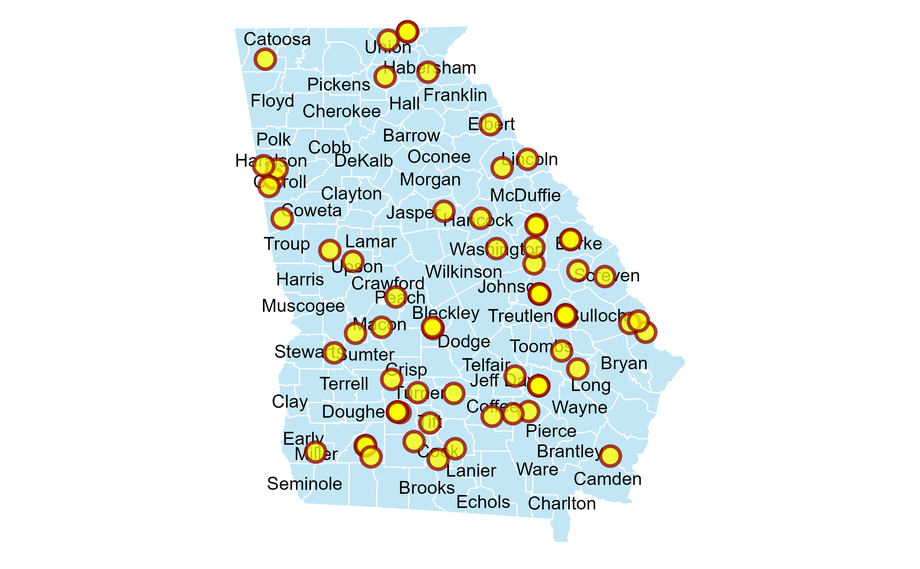
Georgia RHCs Map
ggplot(ga_county_simple)+geom_sf( fill ="skyblue", colour ="white", alpha =0.5)+geom_sf_text(aes(geometry =geometry, label =NAME), size =2.5, check_overlap =TRUE)+geom_jitter( data =geo_census, mapping =aes(long, lat), fill ="yellow", color ="darkred", alpha =0.75, size =3, shape =21, stroke =1)+theme_void()